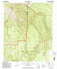
1995 Map of Mount Taylor
USGS Topo · Published 1998About this map
Mount Taylor dominates this 1995 topographic landscape within the San Mateo Mountains, a high-elevation region of New Mexico where multiple land grants and sovereign borders converge. The map illustrates a complex geography of land ownership, including the Laguna Indian Reservation, the Cebolleta Grant, and the Cubero Grant. These large tracts are bisected by deep drainages such as Water Canyon and Timber Canyon, defining a terrain where water sources are vital but scattered. Numerous water points, including Raton Spring, Trough Spring, and De Arman Spring, are meticulously plotted across the high country. Human infrastructure is sparse, characterized primarily by the Microwave Station and an Indian Reservation Boundary that carves through the lower valleys. This map serves as a detailed record of the 1990s intersection between federal land management and traditional tribal and grant boundaries.
Find a feature on this map
28 named features on this map. Tap any name to fly to it.
Don’t see what you’re looking for? This feature index may not catch every label — zoom into the map to look around manually.
Map Details
Editions of this 1995 Mount Taylor Map
This is the sole edition of this map. No revisions or reprints were ever made.
Other maps of this area

1883 · Mt. Taylor
USGS Topo · 1:250,000

1886 · Mt. Taylor
USGS Topo · 1:250,000

1892 · Mt. Taylor
USGS Topo · 1:250,000

1899 · Mt. Taylor
USGS Topo · 1:250,000

1957 · Lobo Springs
USGS Topo · 1:24,000

1957 · Mount Taylor
USGS Topo · 1:24,000

1957 · Laguna
USGS Topo · 1:24,000

1957 · Mc Cartys
USGS Topo · 1:24,000

1957 · Cubero
USGS Topo · 1:24,000

1957 · Seboyeta
USGS Topo · 1:24,000