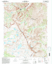
1994 Map of Mount Tom
USGS Topo · Published 1997About this map
Mount Tom and Mt Humphreys tower over this high-elevation landscape on the boundary between the Sierra National Forest and Inyo National Forest. This 1994 revision captures a specialized industrial footprint amidst the protected peaks of the John Muir Wilderness, most notably the Pine Creek Tungsten Mill and an associated Tungsten Mine. These features reflect the region's mid-century mining legacy, persisting long after the wilderness designations of the 1960s. Below the granite walls, French Canyon and Humphreys Basin are defined by a dense concentration of glacial tarns, including Desolation Lake, Steelhead Lake, and the aptly named Honeymoon Lake. The map details the transition between Inyo and Fresno counties at Pine Creek Pass, providing a clear record of the trails and water systems like Morgan Creek that supported both resource extraction and backcountry exploration in the late twentieth century.
Find a feature on this map
60 named features on this map. Tap any name to fly to it.
Don’t see what you’re looking for? This feature index may not catch every label — zoom into the map to look around manually.
Map Details
Editions of this 1994 Mount Tom Map
This is the sole edition of this map. No revisions or reprints were ever made.
Other maps of this area

1912 · Mt. Goddard
USGS Topo · 1:125,000

1947 · Mariposa
USGS Topo · 1:250,000

1948 · Mariposa
USGS Topo · 1:250,000

1948 · Mt. Goddard
USGS Topo · 1:62,500

1949 · Mt. Tom
USGS Topo · 1:62,500

1951 · Mt. Tom
USGS Topo · 1:62,500

1951 · Mt. Goddard
USGS Topo · 1:62,500

1952 · Mt. Goddard
USGS Topo · 1:62,500

1953 · Mt Abbot
USGS Topo · 1:62,500

1953 · Blackcap Mtn
USGS Topo · 1:62,500