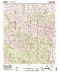
1998 Map of Mount Turnbull
USGS Topo · Published 2002About this map
The Santa Teresa Mountains dominate this 1998 survey of eastern Arizona, where the San Carlos Indian Reservation meets the northern boundary of the Coronado National Forest. This high-altitude landscape is characterized by prominent peaks like Mount Turnbull and Quartzite Mountain, alongside specialized terrain features such as Stanley Butte and Limestone Mountain. The map reveals a history of resource extraction, particularly in the northwest corner near the Starlight Mine and various Mine Shafts. Water sources are critical identifiers in this environment, with labels for Post Office Spring, Hinton Springs, and Grapevine Spring marking essential points of interest for historical land use. The presence of the Indian Treaty Boundary cutting through the canyons of Kelly Gulch and Sycamore Gulch provides a clear look at the jurisdictional demarcations of the late 20th century.
Find a feature on this map
52 named features on this map. Tap any name to fly to it.
Don’t see what you’re looking for? This feature index may not catch every label — zoom into the map to look around manually.
Map Details
Editions of this 1998 Mount Turnbull Map
This is the sole edition of this map. No revisions or reprints were ever made.
Other maps of this area

1938 · Klondyke
USGS Topo · 1:48,000

1943 · Klondyke
USGS Topo · 1:62,500

1944 · Jackson Mtn.
USGS Topo · 1:62,500

1946 · Jackson Mtn.
USGS Topo · 1:62,500

1954 · Mesa
USGS Topo · 1:250,000

1956 · Tucson
USGS Topo · 1:250,000

1957 · Mesa
USGS Topo · 1:250,000

1958 · Mesa
USGS Topo · 1:250,000

1958 · Tucson
USGS Topo · 1:250,000

1959 · Tucson
USGS Topo · 1:250,000