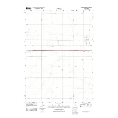
2012 Map of Mount Vernon
USGS Topo · Published 2012About this map
Enemy Creek meanders through this portion of Davison County, defining the drainage patterns of the agricultural landscape surrounding Mount Vernon. The township's orderly grid of section roads, including 251st St and 397th Ave, reflects the long-standing rectangular survey system. Within this rural expanse, the Quaker Cemetery serves as a significant site for local genealogy, marking the resting place of early settlers. The town center is detailed with a precise street plan featuring South Main Street and Railroad Street, illustrating the historic influence of the rail corridor on the community's layout. To the southeast, the presence of the Nicolaisen Airport adds a modern aviation element to this traditional farming region.
Find a feature on this map
24 named features on this map. Tap any name to fly to it.
Don’t see what you’re looking for? This feature index may not catch every label — zoom into the map to look around manually.
Map Details
Editions of this 2012 Mount Vernon Map
This is the sole edition of this map. No revisions or reprints were ever made.
Other maps of this area

1899 · Mitchell
USGS Topo · 1:125,000

1955 · Mitchell
USGS Topo · 1:250,000

1959 · Mitchell
USGS Topo · 1:250,000
1979 · Letcher SW
USGS Topo · 1:24,000

1979 · Storla SW
USGS Topo · 1:24,000

1979 · Storla
USGS Topo · 1:24,000

1980 · Stickney
USGS Topo · 1:24,000

1980 · Old Stickney Lake
USGS Topo · 1:24,000
1980 · Mitchell SW
USGS Topo · 1:24,000

1980 · Mount Vernon
USGS Topo · 1:24,000