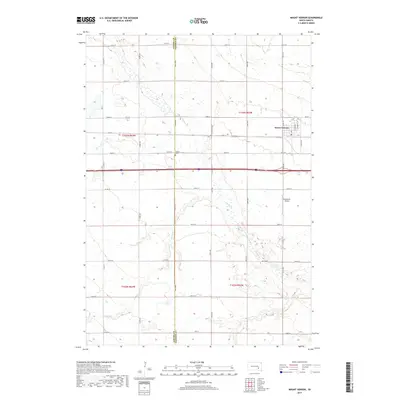
2017 Map of Mount Vernon
USGS Topo · Published 2017About this map
The town of Mount Vernon serves as the primary hub in this portion of South Dakota, situated near the western edge of Davison Co. The landscape is defined by the agricultural grid of the Great Plains, where numerous section-line roads such as 394th Ave and 254th St provide structure to the rural expanse. Water from Enemy Cr meanders southward through the center of the sheet, crossing the boundary between Aurora and Davison counties. Near the center of the map, the Quaker Cem sits along the section road, a small but vital landmark for genealogists tracing early families in the township. To the southeast of the main settlement, the Nicolaisen Airport reflects the integration of aviation into the rural economy, while the primary east-west corridor of Interstate 90 bisects the area, linking these farming communities to larger regional centers.
Find a feature on this map
32 named features on this map. Tap any name to fly to it.
Don’t see what you’re looking for? This feature index may not catch every label — zoom into the map to look around manually.
Map Details
Editions of this 2017 Mount Vernon Map
This is the sole edition of this map. No revisions or reprints were ever made.
Other maps of this area
1899 · Mitchell
USGS Topo · 1:125,000
1955 · Mitchell
USGS Topo · 1:250,000
1959 · Mitchell
USGS Topo · 1:250,000
1979 · Letcher SW
USGS Topo · 1:24,000
1979 · Storla SW
USGS Topo · 1:24,000
1979 · Storla
USGS Topo · 1:24,000
1980 · Stickney
USGS Topo · 1:24,000
1980 · Old Stickney Lake
USGS Topo · 1:24,000
1980 · Mitchell SW
USGS Topo · 1:24,000
1980 · Mount Vernon
USGS Topo · 1:24,000