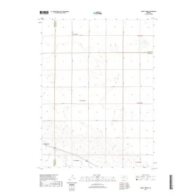
2017 Map of Mount Vernon
USGS Topo · Published 2017About this map
Lodgepole sits in the southwestern corner of this Nebraska High Plains landscape, situated along the banks of Lodgepole Cr. The map reveals a highly structured rural grid, where the boundaries of Cheyenne, Garden, and Deuel counties meet. This transition between counties is marked by a network of sectional roads, including the long east-west corridor of Rd 32 and Rd 24. The area around Mount Vernon demonstrates the characteristic land division of the region, where the vast open spaces are partitioned by a systematic road network such as 3 Mi Rd and Rd 155. The topography is defined by subtle drainage patterns and depressions that contrast with the geometric precision of the township and range lines.
Find a feature on this map
25 named features on this map. Tap any name to fly to it.
Don’t see what you’re looking for? This feature index may not catch every label — zoom into the map to look around manually.
Map Details
Editions of this 2017 Mount Vernon Map
This is the sole edition of this map. No revisions or reprints were ever made.
Other maps of this area

1899 · Sidney
USGS Topo · 1:125,000

1900 · Chappell
USGS Topo · 1:125,000

1954 · Scottsbluff
USGS Topo · 1:250,000

1958 · Scottsbluff
USGS Topo · 1:250,000

1961 · Chappell
USGS Topo · 1:24,000

1971 · Oshkosh SW
USGS Topo · 1:24,000

1971 · Chappell NW
USGS Topo · 1:24,000

1972 · Lodgepole
USGS Topo · 1:24,000

1972 · Lisco SW
USGS Topo · 1:24,000
1972 · Lodgepole SE
USGS Topo · 1:24,000