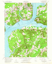
1956 Map of Mount Vernon
USGS Topo · Published 1965About this map
Mount Vernon stands as the historic centerpiece of this mid-century landscape along the Potomac River, where suburban expansion in Virginia meets the more rural stretches of Maryland. The post-war growth of Fairfax County is evident in established and emerging residential areas like Hollin Hills, Hybla Valley, and Woodley Hills, alongside schools such as Drew Smith Sch and Hollin Hall Sch. Across the river, the Maryland shore retains a more dispersed character, featuring the amusement grounds at Marshall Hall and the community of Accokeek. The map reveals the strategic importance of the riverbanks through Fort Hunt National Park and Fort Washington Park, while smaller landmarks like Harmony Hall and Hosley Memorial Chapel provide touchstones for local genealogists. River navigation is detailed with soundings and features like Greenway Flats and various Hulks visible near Broad Creek.
Find a feature on this map
83 named features on this map. Tap any name to fly to it.
Don’t see what you’re looking for? This feature index may not catch every label — zoom into the map to look around manually.
Map Details
Editions of this 1956 Mount Vernon Map
2 editions found
Other maps of this area

1890 · Mt. Vernon
USGS Topo · 1:125,000

1891 · Mt. Vernon
USGS Topo · 1:125,000

1892 · Brandywine
USGS Topo · 1:62,500

1894 · Mt. Vernon
USGS Topo · 1:125,000

1895 · Brandywine
USGS Topo · 1:62,500

1897 · Mt. Vernon
USGS Topo · 1:125,000

1899 · Patuxent
USGS Topo · 1:125,000

1900 · Washington
USGS Topo · 1:62,500

1906 · Patuxent
USGS Topo · 1:125,000

1911 · Brandywine
USGS Topo · 1:62,500