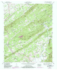
1946 Map of Mount Vernon
USGS Topo · Published 1984About this map
Mount Vernon serves as the primary settlement in this 1946 Tennessee Valley Authority survey of Monroe County, situated amidst a complex landscape of ridges and creek systems. The terrain is defined by Notchy Ridge and the winding Tellico River, which includes the historic Tellico Ferry crossing near Wies Mtn. Rural life is etched into the landscape through numerous community institutions, from the Bethlehem Cem and Bethlehem Ch to smaller schools like Connahanee Sch.
Find a feature on this map
97 named features on this map. Tap any name to fly to it.
Don’t see what you’re looking for? This feature index may not catch every label — zoom into the map to look around manually.
Map Details
Editions of this 1946 Mount Vernon Map
4 editions found
Other maps of this area

1893 · Murphy
USGS Topo · 1:125,000

1895 · Loudon
USGS Topo · 1:125,000

1914 · Murphy
USGS Topo · 1:125,000

1933 · Haw Knob
USGS Topo · 1:48,000

1933 · Bald River Falls
USGS Topo · 1:24,000

1933 · Rafter
USGS Topo · 1:24,000

1934 · Mount Vernon
USGS Topo · 1:24,000

1934 · Mecca
USGS Topo · 1:24,000

1934 · Englewood
USGS Topo · 1:24,000

1934 · Tellico Plains
USGS Topo · 1:24,000