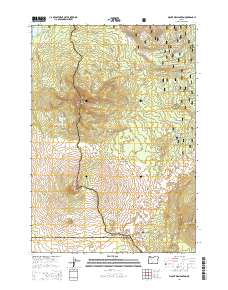
2014 Map of Mount Washington
USGS Topo · Published 2014About this map
Mount Washington stands as the central landmark of this high-altitude survey, marking the intersection of the Willamette National Forest and Deschutes National Forest. The map documents a landscape defined by volcanic geology and historical transit corridors through the Cascade Range. Significant geological features like Belknap Crater, Little Belknap, and Black Crater punctuate the terrain, illustrating the dramatic volcanic history of the region. The map traces the modern path of the Pacific Crest National Scenic Trail as it winds past Washington Ponds and Big Lake. Historically significant routes are also visible, including the Old Santiam Wagon Rd and the Toll Station Rd, which follow the northern contours of the peaks. At the southern edge, the McKenzie Hwy ascends toward McKenzie Pass, passing through basaltic fields near Lava Camp Lake and the overlook at Windy Point.
Find a feature on this map
34 named features on this map. Tap any name to fly to it.
Don’t see what you’re looking for? This feature index may not catch every label — zoom into the map to look around manually.
Map Details
Editions of this 2014 Mount Washington Map
This is the sole edition of this map. No revisions or reprints were ever made.
Other maps of this area

1929 · Three Sisters
USGS Topo · 1:125,000

1932 · Three Sisters
USGS Topo · 1:125,000

1955 · Bend
USGS Topo · 1:250,000

1957 · Bend
USGS Topo · 1:250,000

1958 · Bend
USGS Topo · 1:250,000

1959 · Broken Top
USGS Topo · 1:62,500
1959 · Three Sisters
USGS Topo · 1:62,500

1959 · Three Fingered Jack
USGS Topo · 1:62,500

1959 · Sisters
USGS Topo · 1:62,500
1980 · Bend
USGS Topo · 1:100,000