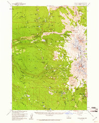
1959 Map of Three Sisters
USGS Topo · Published 1961About this map
South Sister and Middle Sister dominate this high-altitude landscape of the Cascade Range, which is defined by massive lava flows and numerous volcanic features. At the time of this late-1950s survey, the area was largely accessible by a network of trails, including the Oregon Skyline Trail and Obsidian Trail, reflecting its development as a managed wilderness under the Willamette National Forest and Deschutes National Forest. The map documents a system of recreational infrastructure and mountain lookouts, such as Sunshine Shelter and the Scott Mtn VABM Lookout. Geologic markers like Rock Mesa and the wide Wickiup Plain illustrate the complex volcanic history of the region. Scattered seasonal sites such as Knobs Sheep Camp and several forest camps indicate the specialized land use in this high-desert-to-mountain transition during the mid-20th century.
Find a feature on this map
158 named features on this map. Tap any name to fly to it.
Don’t see what you’re looking for? This feature index may not catch every label — zoom into the map to look around manually.
Map Details
Editions of this 1959 Three Sisters Map
3 editions found
Other maps of this area

1925 · Waldo Lake
USGS Topo · 1:125,000

1929 · Three Sisters
USGS Topo · 1:125,000

1930 · Maiden Peak
USGS Topo · 1:125,000

1932 · Three Sisters
USGS Topo · 1:125,000

1934 · Maiden Peak
USGS Topo · 1:125,000

1934 · Mc Kenzie Bridge
USGS Topo · 1:96,000

1940 · Mc Kenzie Bridge
USGS Topo · 1:125,000

1953 · Salem
USGS Topo · 1:250,000

1954 · Salem
USGS Topo · 1:250,000

1955 · Chucksney Mtn
USGS Topo · 1:62,500