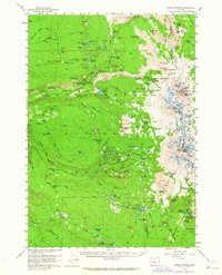
1959 Map of Three Sisters
USGS Topo · Published 1964About this map
Glaciated peaks and volcanic fields define this 1959 survey of the High Cascades, where the Lane Co Deschutes Co boundary crosses the summit of the North Sister and Middle Sister. This era was critical for recreational infrastructure within the Willamette National Forest, as evidenced by the network of seasonal locations like the White Branch Youth Camp and the Devils Garden Forest Camp. The map serves as a detailed record of the mid-century wilderness before significant modern trail realignments, showcasing the original route of the Oregon Skyline Trail as it traverses the Cinder Field and skirts the Collier Glacier. High-altitude shelters such as the Sunshine Shelter and James Creek Shelter provided refuge for travelers navigating the volcanic terrain near Obsidian Cliffs and the Lava flows of the Branch. For those researching the geography of the central Oregon range, the sheet names numerous water features including Linton Lake and the Tenas Lakes.
Find a feature on this map
140 named features on this map. Tap any name to fly to it.
Don’t see what you’re looking for? This feature index may not catch every label — zoom into the map to look around manually.
Map Details
Editions of this 1959 Three Sisters Map
3 editions found
Other maps of this area

1925 · Waldo Lake
USGS Topo · 1:125,000

1929 · Three Sisters
USGS Topo · 1:125,000

1930 · Maiden Peak
USGS Topo · 1:125,000

1932 · Three Sisters
USGS Topo · 1:125,000

1934 · Maiden Peak
USGS Topo · 1:125,000

1934 · Mc Kenzie Bridge
USGS Topo · 1:96,000

1940 · Mc Kenzie Bridge
USGS Topo · 1:125,000

1953 · Salem
USGS Topo · 1:250,000

1954 · Salem
USGS Topo · 1:250,000

1955 · Chucksney Mtn
USGS Topo · 1:62,500