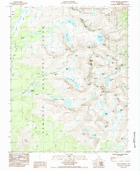
1985 Map of Mount Whitney
USGS Topo · Published 1985About this map
Mount Whitney towers over the high sierra divide in this mid-1980s record, marking the border where Sequoia National Park meets the Inyo National Forest. The landscape is defined by its extreme alpine topography, featuring the intersection of the John Muir Trail and the Pacific Crest National Scenic Trail. Historically significant sites like the Crabtree Ranger Station provide a human anchor amidst the collection of high-altitude features such as Tulainyo Lake and the Hitchcock Lakes. The map traces the rugged path of Lone Pine Creek and Crabtree Creek, revealing the intricate drainage patterns that feed into Mirror Lake and Guitar Lake. This provisional survey preserves the nomenclature of the era, from the sheer granite of Keeler Needle to the broad expanse of Clyde Meadow.
Find a feature on this map
67 named features on this map. Tap any name to fly to it.
Don’t see what you’re looking for? This feature index may not catch every label — zoom into the map to look around manually.
Map Details
Editions of this 1985 Mount Whitney Map
This is the sole edition of this map. No revisions or reprints were ever made.
Other maps of this area

1905 · Olancha
USGS Topo · 1:125,000

1907 · Olancha
USGS Topo · 1:125,000

1907 · Mt. Whitney
USGS Topo · 1:125,000

1919 · Mt. Whitney
USGS Topo · 1:125,000

1937 · Mt. Whitney
USGS Topo · 1:125,000

1948 · Fresno
USGS Topo · 1:250,000

1955 · Fresno
USGS Topo · 1:250,000

1956 · Fresno
USGS Topo · 1:250,000

1956 · Mount Whitney
USGS Topo · 1:62,500

1956 · Olancha
USGS Topo · 1:62,500