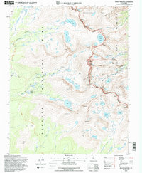
1994 Map of Mount Whitney
USGS Topo · Published 1997About this map
Mount Whitney towers at the center of this high-altitude survey, marking the dramatic boundary between Sequoia National Park and Inyo National Forest. The landscape is defined by its glacial architecture and extreme elevation, featuring massive granite formations like Wotans Throne and the sharp spire of Keeler Needle. In the northern section, the Bighorn Sheep Zoological Area underscores the specialized ecological protections of the region.
Find a feature on this map
88 named features on this map. Tap any name to fly to it.
Don’t see what you’re looking for? This feature index may not catch every label — zoom into the map to look around manually.
Map Details
Editions of this 1994 Mount Whitney Map
This is the sole edition of this map. No revisions or reprints were ever made.
Other maps of this area

1905 · Olancha
USGS Topo · 1:125,000

1907 · Olancha
USGS Topo · 1:125,000

1907 · Mt. Whitney
USGS Topo · 1:125,000

1919 · Mt. Whitney
USGS Topo · 1:125,000

1937 · Mt. Whitney
USGS Topo · 1:125,000

1948 · Fresno
USGS Topo · 1:250,000

1955 · Fresno
USGS Topo · 1:250,000

1956 · Fresno
USGS Topo · 1:250,000

1956 · Mount Whitney
USGS Topo · 1:62,500

1956 · Olancha
USGS Topo · 1:62,500