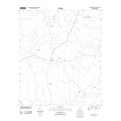
2011 Map of Mount Willing
USGS Topo · Published 2011About this map
Mount Willing serves as a central hub in this section of Lowndes County, where the rural Alabama landscape is defined by its creek systems and family-linked landmarks. The settlement pattern reflects long-standing community roots, anchored by the Mount Willing Cemetery, Lee Cemetery, and Temple Gate Cemetery. Notable infrastructure includes the Mount Willing Lookout Tower and the small Beechwood Airport in the northeast near Dan S Hagood Lake. Waterways like Dry Cedar Creek, Haynes Creek, and Hog Creek create a branching network across the terrain, while roads such as Sellers Dirt Rd and Blue Hill Rd connect scattered homesteads and the smaller settlements of Hammond and Lum. This modern survey provides a detailed view of the rural south just before the widespread digital shifts in local mapping.
Find a feature on this map
33 named features on this map. Tap any name to fly to it.
Don’t see what you’re looking for? This feature index may not catch every label — zoom into the map to look around manually.
Map Details
Editions of this 2011 Mount Willing Map
This is the sole edition of this map. No revisions or reprints were ever made.
Other maps of this area

1953 · Montgomery
USGS Topo · 1:250,000

1953 · Andalusia
USGS Topo · 1:250,000

1956 · Montgomery
USGS Topo · 1:250,000

1957 · Montgomery
USGS Topo · 1:250,000

1957 · Andalusia
USGS Topo · 1:250,000

1957 · Braggs
USGS Topo · 1:62,500

1971 · Fort Deposit
USGS Topo · 1:24,000

1971 · Fort Dale
USGS Topo · 1:24,000
1981 · Calhoun
USGS Topo · 1:24,000
1981 · Hayneville
USGS Topo · 1:24,000