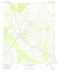
1981 Map of Hayneville
USGS Topo · Published 1981About this map
Hayneville serves as the focal point of this Lowndes County landscape, situated at the confluence of several regional roads in a terrain defined by broad creek bottoms. The settlement is anchored by local institutions including the High Sch and an Athletic Field, surrounded by several historic burial grounds such as Hayneville Cem and the Mushat-Gilchrist Cem. The map reveals a community organized around its spiritual and family foundations, with numerous rural houses of worship like Baptist Hill Ch and Shiloh Ch scattered through the countryside.
Find a feature on this map
18 named features on this map. Tap any name to fly to it.
Don’t see what you’re looking for? This feature index may not catch every label — zoom into the map to look around manually.
Map Details
Editions of this 1981 Hayneville Map
This is the sole edition of this map. No revisions or reprints were ever made.
Other maps of this area

1927 · Montgomery
USGS Topo · 1:48,000

1930 · Montgomery
USGS Topo · 1:62,500

1953 · Montgomery
USGS Topo · 1:250,000

1956 · Montgomery
USGS Topo · 1:250,000

1957 · Montgomery
USGS Topo · 1:250,000

1957 · Letohatchee
USGS Topo · 1:62,500

1957 · Autaugaville
USGS Topo · 1:62,500

1958 · Montgomery
USGS Topo · 1:62,500

1975 · Autaugaville SW
USGS Topo · 1:24,000

1975 · Autaugaville SE
USGS Topo · 1:24,000