
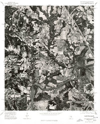
1975 Map of Autaugaville SE
USGS Topo · Published 1977About this map
The Alabama River winds through the northern portion of this 1975 orthophotoquad, defining a landscape of sharp relief between the river valley and the agricultural uplands of Lowndes County. This specific aerial perspective, captured in December of 1975, reveals the settlement of Burkville situated along the rail and road corridors that parallel the river’s course. Unlike traditional topographic maps, this imagery provides a direct view of land use patterns, showing the precise distribution of woodlots, cleared fields, and the transportation infrastructure that connected these rural communities. The winding path of the river, with its sandbars and steep banks, dominates the northern quadrant, while the southern reaches are characterized by a patchwork of large-scale agriculture and forest, reflecting the economic transition of the mid-1970s.
Find a feature on this map
2 named features on this map. Tap any name to fly to it.
Don’t see what you’re looking for? This feature index may not catch every label — zoom into the map to look around manually.
Map Details
Editions of this 1975 Autaugaville SE Map
This is the sole edition of this map. No revisions or reprints were ever made.
Other maps of this area

1927 · Montgomery
USGS Topo · 1:48,000

1930 · Montgomery
USGS Topo · 1:62,500

1953 · Montgomery
USGS Topo · 1:250,000

1956 · Montgomery
USGS Topo · 1:250,000

1957 · Montgomery
USGS Topo · 1:250,000

1957 · Letohatchee
USGS Topo · 1:62,500

1957 · Autaugaville
USGS Topo · 1:62,500

1958 · Montgomery
USGS Topo · 1:62,500

1975 · Autaugaville SW
USGS Topo · 1:24,000
1975 · Montgomery NW
USGS Topo · 1:24,000