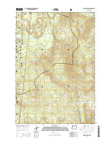
2014 Map of Mount Wilson
USGS Topo · Published 2014About this map
Mount Hood National Forest provides the backdrop for this high-altitude landscape where the headwaters of the Oak Grove Fork Clackamas River and Warm Springs River originate. The rugged spine of the Cascades is marked by the presence of the Pacific Crest National Scenic Trail, which traverses the western half of the sheet past Summit Butte and through Red Wolf Pass. This 2014 survey documents a network of forest service roads, including the Oregon Skyline Rd and Mt Wilson Lookout Rd, that provide access to the prominent volcanic peaks and ridges. The map highlights the drainage divide between Clackamas Lake and the various tributaries such as Cedar Swamp Cr and Beaver Butte Cr, illustrating the complex hydrology of this mountainous region on the border of Clackamas and Wasco counties.
Find a feature on this map
50 named features on this map. Tap any name to fly to it.
Don’t see what you’re looking for? This feature index may not catch every label — zoom into the map to look around manually.
Map Details
Editions of this 2014 Mount Wilson Map
This is the sole edition of this map. No revisions or reprints were ever made.
Other maps of this area

1924 · Mount Hood
USGS Topo · 1:125,000

1927 · Mount Hood
USGS Topo · 1:125,000

1927 · Mt. Jefferson
USGS Topo · 1:125,000

1930 · Mt. Jefferson
USGS Topo · 1:125,000

1953 · The Dalles
USGS Topo · 1:250,000

1955 · Bend
USGS Topo · 1:250,000

1956 · The Dalles
USGS Topo · 1:250,000

1956 · High Rock
USGS Topo · 1:62,500

1956 · Mt. Wilson
USGS Topo · 1:62,500

1957 · Bend
USGS Topo · 1:250,000