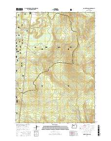
2017 Map of Mount Wilson
USGS Topo · Published 2017About this map
Mt Wilson dominates this section of the Mount Hood National Forest, where the high Cascades terrain dictates a complex network of forestry and pioneer routes. The Oregon Skyline Rd and the Pacific Crest National Scenic Trail traverse the western slopes, tracing the height of land near Clackamas Lake. The drainage patterns here are distinct, with the Oak Grove Fork Clackamas River flowing through Big Meadows in the north, while the southern reaches of the map feed into the Warm Springs River. Significant elevation markers like Buckskin Butte, Wests Butte, and Summit Butte define the ridgelines. The presence of Mount Wilson Schoolie Rd suggests historical access routes through this timber-rich landscape, which straddles the boundary between Clackamas and Wasco counties.
Find a feature on this map
45 named features on this map. Tap any name to fly to it.
Don’t see what you’re looking for? This feature index may not catch every label — zoom into the map to look around manually.
Map Details
Editions of this 2017 Mount Wilson Map
This is the sole edition of this map. No revisions or reprints were ever made.
Other maps of this area

1924 · Mount Hood
USGS Topo · 1:125,000

1927 · Mount Hood
USGS Topo · 1:125,000

1927 · Mt. Jefferson
USGS Topo · 1:125,000

1930 · Mt. Jefferson
USGS Topo · 1:125,000

1953 · The Dalles
USGS Topo · 1:250,000

1955 · Bend
USGS Topo · 1:250,000

1956 · The Dalles
USGS Topo · 1:250,000

1956 · High Rock
USGS Topo · 1:62,500

1956 · Mt. Wilson
USGS Topo · 1:62,500

1957 · Bend
USGS Topo · 1:250,000