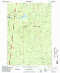
1996 Map of Mount Wilson
USGS Topo · Published 1998About this map
The boundary between the Mount Hood National Forest and the Warm Springs Indian Reservation divides this landscape, following the historic Pacific Crest National Scenic Trail (Mc Quinn Line 1887). This 1990s survey by the Forest Service highlights a high-elevation region of the Cascade Range where the headwaters of the Clackamas River and Warm Springs River originate. The western portion is characterized by recreational hubs such as the Joe Graham Horse Camp and the expansive Big Meadows.
Find a feature on this map
26 named features on this map. Tap any name to fly to it.
Don’t see what you’re looking for? This feature index may not catch every label — zoom into the map to look around manually.
Map Details
Editions of this 1996 Mount Wilson Map
This is the sole edition of this map. No revisions or reprints were ever made.
Other maps of this area

1924 · Mount Hood
USGS Topo · 1:125,000

1927 · Mount Hood
USGS Topo · 1:125,000

1927 · Mt. Jefferson
USGS Topo · 1:125,000

1930 · Mt. Jefferson
USGS Topo · 1:125,000

1953 · The Dalles
USGS Topo · 1:250,000

1955 · Bend
USGS Topo · 1:250,000

1956 · The Dalles
USGS Topo · 1:250,000

1956 · High Rock
USGS Topo · 1:62,500

1956 · Mt. Wilson
USGS Topo · 1:62,500

1957 · Bend
USGS Topo · 1:250,000