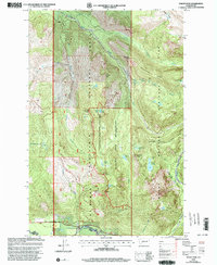
2000 Map of Mount Wow
USGS Topo · Published 2003About this map
The Mount Rainier National Park boundary defines the eastern half of this landscape, where the high ridges of Klapatche Ridge and Emerald Ridge overlook a network of glacial river valleys. A significant commemorative site, the Marine Memorial Airplane Crash Monument, sits near Round Pass, marking a point of interest for local history and aviation researchers. The terrain transitions westward into the Glacier View Wilderness, a region dominated by high peaks like Mt Beljica and isolated water bodies such as Lake George and Lake Christine. Drainage patterns are governed by the Puyallup River and Nisqually River, which are fed by numerous high-altitude cascades including Larrupin Falls and Ethania Falls. The presence of a Patrol Cabin and Patrol Cabin Shelter along the wilderness trails reflects the mid-century infrastructure managed by the Forest Service across the Mount Baker-Snoqualmie National Forest.
Find a feature on this map
44 named features on this map. Tap any name to fly to it.
Don’t see what you’re looking for? This feature index may not catch every label — zoom into the map to look around manually.
Map Details
Editions of this 2000 Mount Wow Map
This is the sole edition of this map. No revisions or reprints were ever made.
Other maps of this area

1924 · Mt Rainier
USGS Topo · 1:96,000

1928 · Mt Rainier
USGS Topo · 1:125,000

1937 · Eatonville
USGS Topo · 1:125,000

1950 · Yakima
USGS Topo · 1:250,000

1953 · Hoquiam
USGS Topo · 1:250,000

1956 · Mineral
USGS Topo · 1:62,500

1956 · Kapowsin
USGS Topo · 1:62,500

1957 · Hoquiam
USGS Topo · 1:250,000

1958 · Yakima
USGS Topo · 1:250,000

1958 · Hoquiam
USGS Topo · 1:250,000