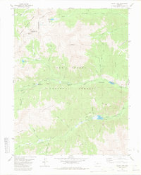
1982 Map of Mount Yale
USGS Topo · Published 1983About this map
The Continental Divide winds along the crest of the high Sawatch Range in this early 1980s survey, marking the boundary between the Gunnison and San Isabel National Forests. Dominated by the soaring peak of Mount Yale, the landscape is a complex network of glacial cirques and high-altitude drainage systems including North Fork Cottonwood Creek, Middle Cottonwood Creek, and South Cottonwood Creek. Human activity is primarily centered on recreation and resource extraction, with established sites like the Collegiate Peaks Campground and various mines dotting the gulches. Mining history is preserved in labels for the Gladstone Mine and Holywater Mine near the Holywater Beaver Ponds. A system of pack trails and jeep trails provides access to remote alpine basins such as those containing Hartenstein Lake and Kroenke Lake, while Cottonwood Lake serves as a more accessible hub with a dedicated Picnic Area.
Find a feature on this map
44 named features on this map. Tap any name to fly to it.
Don’t see what you’re looking for? This feature index may not catch every label — zoom into the map to look around manually.
Map Details
Editions of this 1982 Mount Yale Map
2 editions found
Other maps of this area

1940 · Garfield
USGS Topo · 1:62,500

1945 · Garfield
USGS Topo · 1:62,500

1955 · Buena Vista
USGS Topo · 1:62,500

1955 · Mount Harvard
USGS Topo · 1:62,500

1956 · Poncha Springs
USGS Topo · 1:62,500

1956 · Montrose
USGS Topo · 1:250,000

1959 · Montrose
USGS Topo · 1:250,000

1960 · Montrose
USGS Topo · 1:250,000

1968 · Montrose
USGS Topo · 1:250,000

1982 · Buena Vista West
USGS Topo · 1:24,000