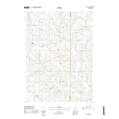
2018 Map of Mount Zion
USGS Topo · Published 2018About this map
Mount Zion and the surrounding coulees of southwest Wisconsin are defined by a complex network of ridges and hollows that bridge the border of Crawford and Richland Counties. The landscape is marked by historic rural settlements like Rolling Ground, Montgomeryville, and Jimtown, which sit atop high ground or along the winding valleys of Knapp Cr and its tributaries. Local history is deeply embedded in the numerous hilltop and valley cemeteries, including Union Hill Cem, Mook Cem, and Tavera Cem, which serve as landmarks for early family farmsteads. The terrain transitions from the steep descent of Sleepy Hollow and Long Hollow to prominent heights such as Saint Phillips Ridge and Harrigan Ridge. This 2018 survey also identifies contemporary features like the Leeward Farm Airport, illustrating how aviation and modern county highways like Co Hwy S have integrated with a topography traditionally shaped by the local creek system.
Find a feature on this map
94 named features on this map. Tap any name to fly to it.
Don’t see what you’re looking for? This feature index may not catch every label — zoom into the map to look around manually.
Map Details
Editions of this 2018 Mount Zion Map
This is the sole edition of this map. No revisions or reprints were ever made.
Other maps of this area

1924 · Gays Mills
USGS Topo · 1:62,500

1926 · Gays Mills
USGS Topo · 1:62,500

1926 · Wauzeka
USGS Topo · 1:62,500

1933 · Boaz
USGS Topo · 1:62,500

1933 · Boscobel
USGS Topo · 1:62,500

1958 · La Crosse
USGS Topo · 1:250,000

1961 · La Crosse
USGS Topo · 1:250,000

1965 · La Crosse
USGS Topo · 1:250,000
1966 · Gays Mills
USGS Topo · 1:62,500

1966 · Boaz
USGS Topo · 1:62,500