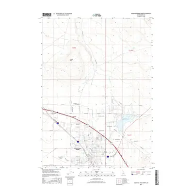
2017 Map of Mountain Home North
USGS Topo · Published 2017About this map
Mountain Home serves as the central hub of this northern Elmore County landscape, where the high desert terrain is defined by a sophisticated network of water management and transportation. The town's northern expansion is clearly visible, anchored by Mountain View Cem and the Mountain Home Municipal Airport. The engineering required to support this community is evident in the numerous waterways that traverse the area, including the Lamberton Canal, Miller Canal, and W Side Canal, which divert water toward the valley. To the north, the topographic relief of Lockman Butte rises above the drainage of Canyon Creek, while the Mountain Home Reservoir and Rattlesnake Cr dominate the eastern reaches. This modern survey provides a detailed look at how the modern grid of Mountain Home meets the older pastoral and volcanic landscape of southern Idaho.
Find a feature on this map
61 named features on this map. Tap any name to fly to it.
Don’t see what you’re looking for? This feature index may not catch every label — zoom into the map to look around manually.
Map Details
Editions of this 2017 Mountain Home North Map
This is the sole edition of this map. No revisions or reprints were ever made.
Other maps of this area

1892 · Mountain Home
USGS Topo · 1:125,000

1893 · Mountain Home
USGS Topo · 1:125,000

1955 · Hailey
USGS Topo · 1:250,000
1956 · Mountain Home South
USGS Topo · 1:24,000

1956 · Crater Rings
USGS Topo · 1:24,000
1956 · Reverse
USGS Topo · 1:24,000

1956 · Mountain Home North
USGS Topo · 1:24,000

1956 · Mountain Home
USGS Topo · 1:62,500
1956 · Crater Rings SE
USGS Topo · 1:24,000

1959 · Hailey
USGS Topo · 1:250,000