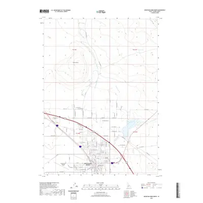
2020 Map of Mountain Home North
USGS Topo · Published 2020About this map
Mountain Home serves as the hub of this Idaho landscape, dominated by a sophisticated network of agricultural irrigation and high-desert terrain. The town's civic heart is anchored by the Elmore County Courthouse and the nearby Mountain View Cem, while the Mountain Home Municipal Airport marks its western periphery. The surrounding high plains are defined by vital water management systems, including the Lamberton Canal, Feeder Canal, and West Side Canal, which divert water to sustain local ranching and farming. North of the city, the land rises toward Lockman Butte, a prominent landmark overlooking the drainage of Canyon Cr. This 2020 record illustrates the enduring importance of water rights in Elmore County, tracing how Rattlesnake Creek and various spring-fed channels like Parker Spring dictate the footprint of modern settlement and infrastructure.
Find a feature on this map
54 named features on this map. Tap any name to fly to it.
Don’t see what you’re looking for? This feature index may not catch every label — zoom into the map to look around manually.
Map Details
Editions of this 2020 Mountain Home North Map
This is the sole edition of this map. No revisions or reprints were ever made.
Other maps of this area

1892 · Mountain Home
USGS Topo · 1:125,000

1893 · Mountain Home
USGS Topo · 1:125,000

1955 · Hailey
USGS Topo · 1:250,000
1956 · Mountain Home South
USGS Topo · 1:24,000

1956 · Crater Rings
USGS Topo · 1:24,000
1956 · Reverse
USGS Topo · 1:24,000

1956 · Mountain Home North
USGS Topo · 1:24,000

1956 · Mountain Home
USGS Topo · 1:62,500
1956 · Crater Rings SE
USGS Topo · 1:24,000

1959 · Hailey
USGS Topo · 1:250,000