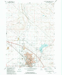
1992 Map of Mountain Home North
USGS Topo · Published 1992About this map
Mountain Home serves as the focal point of this Idaho landscape, showing a structured grid of residential streets and essential civic infrastructure by the early 1990s. The town's layout includes landmarks such as the Mountain Home Cemetery, the Court House, and multiple schools like North Sch and East Sch, alongside the Elmore Memorial Hospital. To the east, the Mountain Home Reservoir is fed by Rattlesnake Cr, while the arid landscape to the north and west is defined by features like Lockman Butte and the winding course of Canyon Creek. A notable historical trace appears in the northeast corner where the Oregon Trail traverses the high ground. The southern portion of the map transitions into the Birds of Prey Area near the Snake River, reflecting the region's environmental significance alongside its role as a transportation hub centered around the Municipal Airport.
Find a feature on this map
51 named features on this map. Tap any name to fly to it.
Don’t see what you’re looking for? This feature index may not catch every label — zoom into the map to look around manually.
Map Details
Editions of this 1992 Mountain Home North Map
This is the sole edition of this map. No revisions or reprints were ever made.
Other maps of this area

1892 · Mountain Home
USGS Topo · 1:125,000

1893 · Mountain Home
USGS Topo · 1:125,000

1955 · Hailey
USGS Topo · 1:250,000
1956 · Mountain Home South
USGS Topo · 1:24,000

1956 · Crater Rings
USGS Topo · 1:24,000
1956 · Reverse
USGS Topo · 1:24,000

1956 · Mountain Home North
USGS Topo · 1:24,000

1956 · Mountain Home
USGS Topo · 1:62,500
1956 · Crater Rings SE
USGS Topo · 1:24,000

1959 · Hailey
USGS Topo · 1:250,000