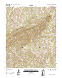
2013 Map of Mountain Valley
USGS Topo · Published 2013About this map
Turkeycock Mountain and its prominent Turkeycock Lookout Tower dominate the central landscape of this part of southern Virginia. The area's topography is defined by significant ridges and gaps, such as Double Oaks Gap and Robertson Mountain, which channel the numerous waterways flowing through the territory. The rural economy of the early 21st century remains tied to its geography, with historic milling sites like Swansons Mill and Hodges Mill situated along the winding creek beds. Small settlements like Mountain Valley, Vashti, and Grady are connected by a network of secondary roads that trace the contours of the land. The drainage patterns are intricate, with Turkeycock Cr and Leatherwood Cr carving through the terrain, eventually feeding into larger systems like the W Fork Sandy River.
Find a feature on this map
86 named features on this map. Tap any name to fly to it.
Don’t see what you’re looking for? This feature index may not catch every label — zoom into the map to look around manually.
Map Details
Editions of this 2013 Mountain Valley Map
This is the sole edition of this map. No revisions or reprints were ever made.
Other maps of this area

1922 · Callands
USGS Topo · 1:48,000

1924 · Martinsville
USGS Topo · 1:48,000

1924 · Draper
USGS Topo · 1:48,000

1924 · Callands
USGS Topo · 1:62,500

1925 · Rocky Mount
USGS Topo · 1:48,000

1926 · Martinsville
USGS Topo · 1:62,500

1926 · Draper
USGS Topo · 1:62,500

1927 · Rocky Mount
USGS Topo · 1:62,500

1927 · Martinsville
USGS Topo · 1:62,500

1944 · Martinsville
USGS Topo · 1:62,500