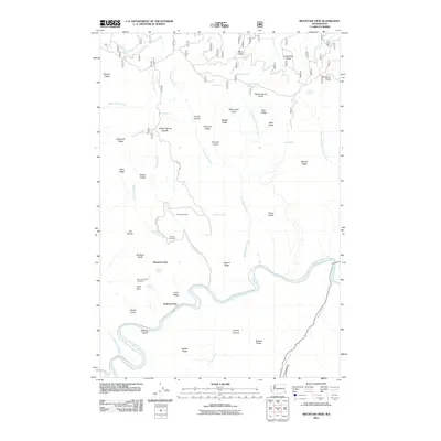
2011 Map of Mountain View
USGS Topo · Published 2011About this map
The Grande Ronde River carves a deep, winding path through this corner of Asotin County, defining a landscape of high ridges and narrow canyons. Near the river's bend, the settlement of Mountain View sits atop the plateau, anchored by the Mountain View Cemetery and the nearby Autrey Cemetery. This area represents a classic inland Northwest transition between high-country ranching and river-bottom transport, where landmarks like Hanson Ferry once provided essential crossings.
Find a feature on this map
54 named features on this map. Tap any name to fly to it.
Don’t see what you’re looking for? This feature index may not catch every label — zoom into the map to look around manually.
Map Details
Editions of this 2011 Mountain View Map
This is the sole edition of this map. No revisions or reprints were ever made.
Other maps of this area

1943 · Saddle Butte
USGS Topo · 1:62,500

1944 · Anatone
USGS Topo · 1:62,500

1946 · Saddle Butte
USGS Topo · 1:62,500

1946 · Anatone
USGS Topo · 1:62,500

1955 · Pullman
USGS Topo · 1:250,000

1955 · Grangeville
USGS Topo · 1:250,000

1958 · Pullman
USGS Topo · 1:250,000

1959 · Grangeville
USGS Topo · 1:250,000

1967 · Troy
USGS Topo · 1:24,000
1967 · Paradise
USGS Topo · 1:24,000