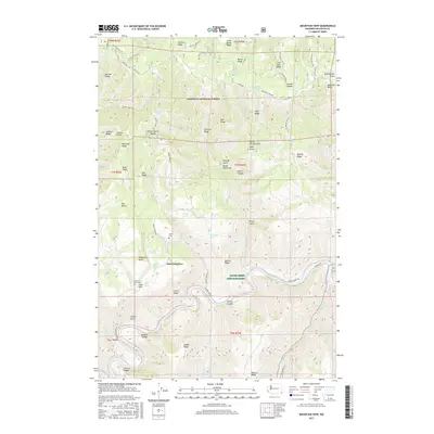
2017 Map of Mountain View
USGS Topo · Published 2017About this map
The Grande Ronde River carves a deep, sinuous path through the southern portion of this Asotin County landscape, where the small settlement of Mountain View is positioned on a high plateau. This 2017 survey reveals a complex network of ridgelines and gulches, including Morrow Ridge and Sweitzer Ridge, within the Umatilla National Forest. The presence of the Mountain View Cem and Autrey Cem near the central drainage of Cougar Cr provides specific points of interest for genealogists tracking early homesteaders in this high-altitude cattle and timber country. The river bottom features McNeill Island and the Lyons Ferry Fish Hatchery, contrasting with the high peaks of Anatone Butte and Whitetail Butte. Numerous springs, such as Swank Springs and Robinson Spring, indicate the vital water sources that supported settlement across the dissected terrain of Hanson Ridge and Corral Ridge.
Find a feature on this map
123 named features on this map. Tap any name to fly to it.
Don’t see what you’re looking for? This feature index may not catch every label — zoom into the map to look around manually.
Map Details
Editions of this 2017 Mountain View Map
This is the sole edition of this map. No revisions or reprints were ever made.
Other maps of this area

1943 · Saddle Butte
USGS Topo · 1:62,500

1944 · Anatone
USGS Topo · 1:62,500

1946 · Saddle Butte
USGS Topo · 1:62,500

1946 · Anatone
USGS Topo · 1:62,500

1955 · Pullman
USGS Topo · 1:250,000

1955 · Grangeville
USGS Topo · 1:250,000

1958 · Pullman
USGS Topo · 1:250,000

1959 · Grangeville
USGS Topo · 1:250,000

1967 · Troy
USGS Topo · 1:24,000
1967 · Paradise
USGS Topo · 1:24,000