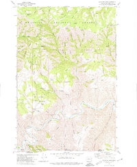
1971 Map of Mountain View
USGS Topo · Published 1974About this map
The Grande Ronde River cuts a deep course through the southeastern corner of Washington, defining a landscape of high ridges and narrow gulches within the Umatilla National Forest. In the early 1970s, this area near the Oregon border was a tapestry of grazing lands and timber, where the small settlement of Mountain View stood near the prominent Mountain View Whitetail Butte. The map reveals a land managed for its natural resources and rugged geography, evidenced by numerous springs such as Seven Sisters Spring and Chile Spring that supported local livestock and forestry operations.
Find a feature on this map
78 named features on this map. Tap any name to fly to it.
Don’t see what you’re looking for? This feature index may not catch every label — zoom into the map to look around manually.
Map Details
Editions of this 1971 Mountain View Map
2 editions found
Other maps of this area

1943 · Saddle Butte
USGS Topo · 1:62,500

1944 · Anatone
USGS Topo · 1:62,500

1946 · Saddle Butte
USGS Topo · 1:62,500

1946 · Anatone
USGS Topo · 1:62,500

1955 · Pullman
USGS Topo · 1:250,000

1955 · Grangeville
USGS Topo · 1:250,000

1958 · Pullman
USGS Topo · 1:250,000

1959 · Grangeville
USGS Topo · 1:250,000

1967 · Troy
USGS Topo · 1:24,000
1967 · Paradise
USGS Topo · 1:24,000