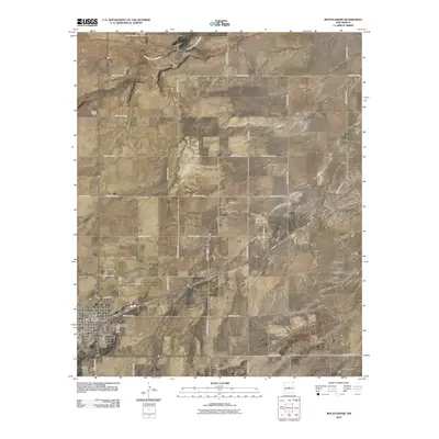
2010 Map of Mountainair
USGS Topo · Published 2010About this map
The town of Mountainair serves as a central hub in Torrance County, defined by a grid of streets and key civic landmarks such as the Mountainair Post Office and the Mountainair Rodeo Ground. This 2010 survey illustrates the blend of aviation and agriculture, with the Mountainair Municipal Airport situated just west of the town center. The surrounding landscape is characterized by wide-ranging ranching operations, including the Hinman Ranch and Bullington Ranch, as well as the outlier settlement of Broncho. These homesteads and small communities are connected by an extensive network of county roads that navigate the arid terrain. Natural drainage patterns are evident through the seasonal courses of Arroyo de Manzano, Mesteno Draw, and Chavez Draw, while local industry is represented by the Mountainair Pit and the Spangler Windmill.
Find a feature on this map
37 named features on this map. Tap any name to fly to it.
Don’t see what you’re looking for? This feature index may not catch every label — zoom into the map to look around manually.
Map Details
Editions of this 2010 Mountainair Map
This is the sole edition of this map. No revisions or reprints were ever made.
Other maps of this area

1917 · Estancia
USGS Topo · 1:125,000

1954 · Torreon
USGS Topo · 1:24,000

1954 · Torreon
USGS Topo · 1:62,500

1954 · Socorro
USGS Topo · 1:250,000

1956 · Mountainair
USGS Topo · 1:62,500

1958 · Socorro
USGS Topo · 1:250,000

1962 · Socorro
USGS Topo · 1:250,000

1972 · Abo
USGS Topo · 1:24,000
1972 · Mesa Draw
USGS Topo · 1:24,000
1972 · Round Top
USGS Topo · 1:24,000