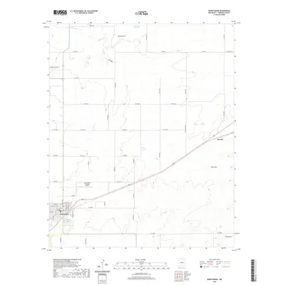
2020 Map of Mountainair
USGS Topo · Published 2020About this map
Mountainair serves as the primary hub in this central New Mexico landscape, situated at a junction of roads and rail corridors that have historically defined the region's transport network. The town's grid is clearly delineated, featuring streets such as Main St, Sunset Ave, and N Summit Ave, while the Mountainair Municipal Airport sits just to the northeast. The surrounding terrain is characterized by a series of significant drainage features, including the Arroyo de Manzano in the north and the deep channels of Mesteno Draw.
Find a feature on this map
49 named features on this map. Tap any name to fly to it.
Don’t see what you’re looking for? This feature index may not catch every label — zoom into the map to look around manually.
Map Details
Editions of this 2020 Mountainair Map
This is the sole edition of this map. No revisions or reprints were ever made.
Other maps of this area

1917 · Estancia
USGS Topo · 1:125,000

1954 · Torreon
USGS Topo · 1:24,000

1954 · Torreon
USGS Topo · 1:62,500

1954 · Socorro
USGS Topo · 1:250,000

1956 · Mountainair
USGS Topo · 1:62,500

1958 · Socorro
USGS Topo · 1:250,000

1962 · Socorro
USGS Topo · 1:250,000

1972 · Abo
USGS Topo · 1:24,000
1972 · Mesa Draw
USGS Topo · 1:24,000
1972 · Round Top
USGS Topo · 1:24,000