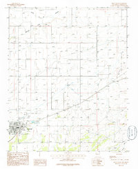
1986 Map of Mountainair
USGS Topo · Published 1986About this map
Mountainair serves as the primary hub of activity in this high-altitude New Mexico landscape, shown here through data field-checked in the early 1980s. The settlement layout includes several community landmarks, such as the Rodeo Ground and a nearby Radio Tower, reflecting the local social and infrastructure needs of the era. The terrain is defined by its drainage patterns, with Arroyo de Manzano and Mesteño Draw cutting across the landscape, while the presence of an Aqueduct and Sewage Disposal Ponds indicates the careful management of water resources in this arid environment. Outside the immediate town center, industrial and transportation features such as the Landing Strip and multiple instances of a Gravel Pit suggest a landscape geared toward utility and regional connectivity. To the southeast, Chavez Draw further illustrates the complex network of natural watercourses that have historically shaped development in Torrance County.
Find a feature on this map
10 named features on this map. Tap any name to fly to it.
Don’t see what you’re looking for? This feature index may not catch every label — zoom into the map to look around manually.
Map Details
Editions of this 1986 Mountainair Map
This is the sole edition of this map. No revisions or reprints were ever made.
Other maps of this area

1917 · Estancia
USGS Topo · 1:125,000

1954 · Torreon
USGS Topo · 1:24,000

1954 · Torreon
USGS Topo · 1:62,500

1954 · Socorro
USGS Topo · 1:250,000

1956 · Mountainair
USGS Topo · 1:62,500

1958 · Socorro
USGS Topo · 1:250,000

1962 · Socorro
USGS Topo · 1:250,000

1972 · Abo
USGS Topo · 1:24,000
1972 · Mesa Draw
USGS Topo · 1:24,000
1972 · Round Top
USGS Topo · 1:24,000