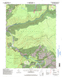
1995 Map of Mozark Mountain
USGS Topo · Published 1998About this map
Blackwater River and Dry Fork converge at the settlement of Hendricks, a focal point for this mountain landscape updated by the Forest Service in the mid-1990s. The map details a transition between protected lands, including the Otter Creek Wilderness and the southern reaches of Blackwater Falls State Park, and the industrial heritage of the Monongahela National Forest. Small communities and landmarks like Gladwin and Brights Chapel are documented alongside natural features such as Mozark Mountain and Backbone Mountain.
Find a feature on this map
41 named features on this map. Tap any name to fly to it.
Don’t see what you’re looking for? This feature index may not catch every label — zoom into the map to look around manually.
Map Details
Editions of this 1995 Mozark Mountain Map
2 editions found
Other maps of this area

1886 · St. George
USGS Topo · 1:125,000

1889 · Beverly
USGS Topo · 1:125,000

1891 · St. George
USGS Topo · 1:125,000

1892 · Beverly
USGS Topo · 1:125,000

1892 · Franklin
USGS Topo · 1:125,000

1895 · Piedmont
USGS Topo · 1:125,000

1896 · Franklin
USGS Topo · 1:125,000

1908 · Parsons
USGS Topo · 1:62,500

1916 · Davis
USGS Topo · 1:48,000

1918 · Davis
USGS Topo · 1:62,500