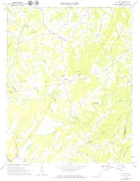
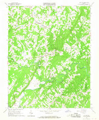
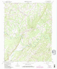
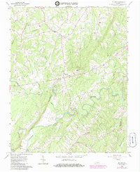
1966 Map of Mt. Airy
USGS Topo · Published 1979About this map
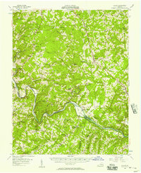
Banister River meanders across this rural landscape in the mid-1960s, defining the agricultural and social rhythm of northern Pittsylvania Co near its border with Halifax Co. The settlement of Mt Airy serves as a central point, supported by community institutions like Mt Airy Sch and St Andrews Ch. To the north, Glenland and Renan anchor a network of country roads, while the southern reaches feature the community of Riceville and the Markham Church at Markham. The terrain is characterized by a dense system of tributary streams, including Straightstone Creek, Flyblow Creek, and Stinking River, which historically dictated land use and property boundaries. Genealogists will find a significant number of unnamed cemeteries scattered throughout the hills, suggesting a long history of family homesteads established well before these 1964 aerial surveys were conducted.
Find a feature on this map
31 named features on this map. Tap any name to fly to it.
Don’t see what you’re looking for? This feature index may not catch every label — zoom into the map to look around manually.
Map Details
Editions of this 1966 Mt. Airy Map
4 editions found
Other maps of this area

1892 · Lynchburg
USGS Topo · 1:125,000

1921 · Chatham
USGS Topo · 1:48,000

1923 · Chatham
USGS Topo · 1:62,500

1947 · Roanoke
USGS Topo · 1:250,000

1951 · Altavista
USGS Topo · 1:62,500

1953 · Greensboro
USGS Topo · 1:250,000

1954 · Greensboro
USGS Topo · 1:250,000

1954 · Riceville
USGS Topo · 1:62,500
1956 · Gladys
USGS Topo · 1:62,500

1959 · Roanoke
USGS Topo · 1:250,000