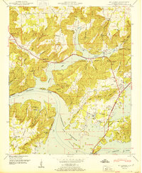
1950 Map of Mt Carmel
USGS Topo · Published 1950About this map
Guntersville Reservoir dominates this 1950 Marshall County landscape, where the waters of the Tennessee River have reshaped the valley's older transport and settlement patterns. The map documents the intricate relationship between the rising reservoir and the rugged terrain of Gunters Mountain and Georgia Mountain. Evidence of the region's ferry-dependent history is visible at the N C & St L Ry Ferry crossing points, which remained vital for connecting small communities like Henryville and Cottonville.
Find a feature on this map
69 named features on this map. Tap any name to fly to it.
Don’t see what you’re looking for? This feature index may not catch every label — zoom into the map to look around manually.
Map Details
Editions of this 1950 Mt Carmel Map
2 editions found
Other maps of this area

1885 · Gadsden
USGS Topo · 1:125,000

1888 · Gadsden
USGS Topo · 1:125,000

1888 · Scottsboro
USGS Topo · 1:125,000

1892 · Scottsboro
USGS Topo · 1:125,000

1892 · Gadsden
USGS Topo · 1:125,000

1895 · Gadsden
USGS Topo · 1:125,000

1903 · Gadsden
USGS Topo · 1:125,000

1936 · Guntersville
USGS Topo · 1:24,000

1936 · Columbus City
USGS Topo · 1:24,000

1936 · New Hope
USGS Topo · 1:24,000