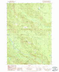
1986 Map of Mt. David Douglas
USGS Topo · Published 1986About this map
Willamette National Forest encompasses this high-elevation terrain in Lane County, dominated by the prominent peaks and ridgelines of the Cascade Range. Rising from the drainage of Salt Creek, the landscape is defined by Mt David Douglas and Koch Mountain. The map detail shows a complex network of forest roads and trails, including the Ranger Trail, weaving through the steep topography of Bunchgrass Ridge. Isolated landmarks such as Verdun Rock and the evocatively named Hells Half Acre dot the ridges, while high-country water features like Spirit Lake and Lucas Lake occupy the basins. To the south, the rail line follows the narrow corridor of the South Fork Salt Creek, passing through remote points like Cruzatte and Snowshed, reflecting the logistical challenges of crossing this mountainous divide in the late twentieth century.
Find a feature on this map
30 named features on this map. Tap any name to fly to it.
Don’t see what you’re looking for? This feature index may not catch every label — zoom into the map to look around manually.
Map Details
Editions of this 1986 Mt. David Douglas Map
This is the sole edition of this map. No revisions or reprints were ever made.
Other maps of this area

1925 · Waldo Lake
USGS Topo · 1:125,000

1955 · Chucksney Mtn
USGS Topo · 1:62,500

1956 · Waldo Lake
USGS Topo · 1:62,500

1956 · Oakridge
USGS Topo · 1:62,500

1956 · Sardine Butte
USGS Topo · 1:62,500

1958 · Roseburg
USGS Topo · 1:250,000

1959 · Roseburg
USGS Topo · 1:250,000

1983 · Oakridge
USGS Topo · 1:100,000
1986 · Willamette Pass
USGS Topo · 1:24,000
1986 · Groundhog Mountain
USGS Topo · 1:24,000