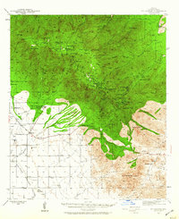
1942 Map of Mt. Graham
USGS Topo · Published 1960About this map
Fort Grant and the adjacent State Industrial School stand at the transition between the high peaks of the Pinaleño Mountains and the arid Sulphur Springs Valley. During the early 1940s, this landscape within the Coronado National Forest featured a network of specialized encampments and agriculture, including a CCC Camp, the Cluff Dairy, and the Angle Orchard Ranch. The high country is dominated by Mt. Graham and Heliograph Peak, accessed via the winding Swift Trail. Family-run ranching operations like the Moyer, Mills, and Pitchfork Ranch define the western foothills, while the Jernigan Ranch and Estes Ranch occupy the lower basins, illustrating the era's reliance on scattered springs and seasonal washes for livestock and settlement.
Find a feature on this map
74 named features on this map. Tap any name to fly to it.
Don’t see what you’re looking for? This feature index may not catch every label — zoom into the map to look around manually.
Map Details
Editions of this 1942 Mt. Graham Map
3 editions found
Other maps of this area

1922 · Willcox
USGS Topo · 1:125,000

1940 · Sierra Bonita Ranch
USGS Topo · 1:62,500

1942 · Sierra Bonita Ranch
USGS Topo · 1:62,500

1942 · Mt. Graham
USGS Topo · 1:62,500

1943 · Willcox
USGS Topo · 1:62,500

1943 · Sierra Bonita Ranch
USGS Topo · 1:62,500

1943 · Winchester Mts.
USGS Topo · 1:62,500

1944 · Jackson Mtn.
USGS Topo · 1:62,500

1944 · Fisher Hills
USGS Topo · 1:62,500

1945 · Mt. Graham
USGS Topo · 1:62,500