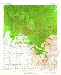
1942 Map of Mt. Graham
USGS Topo · Published 1964About this map
The State Industrial School and Fort Grant (PO) serve as the primary landmarks at the base of the massive Pinaleño Mountains during the 1940s. This survey, mapped by the U.S. Geological Survey and U.S. Forest Service, details the high-altitude landscape of the Coronado National Forest, rising from the Sulphur Springs Valley to the 10,713-foot summit of Mt Graham. The mountain's cooler elevations supported a distinct pattern of settlement and recreation, evidenced by the cluster of summer cabins and facilities at Turkey Flat, the Columbine Ranger Station, and Old Columbine.
Find a feature on this map
68 named features on this map. Tap any name to fly to it.
Don’t see what you’re looking for? This feature index may not catch every label — zoom into the map to look around manually.
Map Details
Editions of this 1942 Mt. Graham Map
3 editions found
Other maps of this area

1922 · Willcox
USGS Topo · 1:125,000

1940 · Sierra Bonita Ranch
USGS Topo · 1:62,500

1942 · Sierra Bonita Ranch
USGS Topo · 1:62,500

1942 · Mt. Graham
USGS Topo · 1:62,500

1943 · Willcox
USGS Topo · 1:62,500

1943 · Sierra Bonita Ranch
USGS Topo · 1:62,500

1943 · Winchester Mts.
USGS Topo · 1:62,500

1944 · Jackson Mtn.
USGS Topo · 1:62,500

1944 · Fisher Hills
USGS Topo · 1:62,500

1945 · Mt. Graham
USGS Topo · 1:62,500