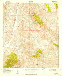
1948 Map of Mt. Hughes
USGS Topo · Published 1953About this map
Moraga Ranch and Harmon Ranch anchor the northern landscape of this post-war ranching territory, where cattle operations are interspersed with the winding canyons of the Coronado National Forest. The Southern Pacific railroad corridor parallels Sonoita Creek, passing through Crittenden and by a vital Water Tank that supported steam-era transport. Family names are etched across the terrain at Stevens Ranch, Seibold Ranch, and Bergier Ranch, indicating the distributed settlement pattern of the Arizona backcountry. Topographic details reveal the transition from the Canelo Hills to the drainage of Harshaw Creek, with signs of the region's extractive history at the Dunham Mine. A Cem and a remote Ranger Station highlight the essential infrastructure of this mid-century high-desert environment.
Find a feature on this map
28 named features on this map. Tap any name to fly to it.
Don’t see what you’re looking for? This feature index may not catch every label — zoom into the map to look around manually.
Map Details
Editions of this 1948 Mt. Hughes Map
This is the sole edition of this map. No revisions or reprints were ever made.
Other maps of this area

1904 · Patagonia
USGS Topo · 1:125,000

1905 · Patagonia
USGS Topo · 1:125,000

1905 · Nogales
USGS Topo · 1:125,000

1922 · Agus Caliente
USGS Topo · 1:62,500

1932 · Lochiel
USGS Topo · 1:62,500

1932 · Elgin
USGS Topo · 1:62,500

1933 · Calabasas
USGS Topo · 1:62,500

1940 · Elgin
USGS Topo · 1:62,500

1947 · Elgin
USGS Topo · 1:62,500

1948 · Canelo Pass
USGS Topo · 1:24,000