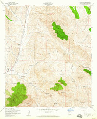
1958 Map of Mt. Hughes
USGS Topo · Published 1960About this map
Patagonia serves as the primary hub of this 1950s landscape, situated along the Southern Pacific railroad line where it follows the course of Sonoita Creek. This era of the Santa Cruz County borderlands is characterized by a transition from established ranching operations like Stevens Ranch and Seibold Ranch to the industrial remains of the region's mining legacy. Evidence of local history is prominent at the Crittenden (Site) and nearby Cemi, reflecting the settlement's earlier role as a rail shipping point.
Find a feature on this map
69 named features on this map. Tap any name to fly to it.
Don’t see what you’re looking for? This feature index may not catch every label — zoom into the map to look around manually.
Map Details
Editions of this 1958 Mt. Hughes Map
3 editions found
Other maps of this area

1904 · Patagonia
USGS Topo · 1:125,000

1905 · Patagonia
USGS Topo · 1:125,000

1905 · Nogales
USGS Topo · 1:125,000

1922 · Agus Caliente
USGS Topo · 1:62,500

1932 · Lochiel
USGS Topo · 1:62,500

1932 · Elgin
USGS Topo · 1:62,500

1933 · Calabasas
USGS Topo · 1:62,500

1940 · Elgin
USGS Topo · 1:62,500

1947 · Elgin
USGS Topo · 1:62,500

1948 · Canelo Pass
USGS Topo · 1:24,000