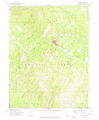
1972 Map of Mt. Ingalls
USGS Topo · Published 1974About this map
Plumas National Forest dominates this topographic study, revealing a landscape shaped by industrial mining and natural drainage within the High Sierra. The northern portion of the map highlights the extensive footprint of the Walker Mine Ruins Tailings and the associated Tailings Pond, signifying the area's history as a significant copper producer before operations ceased. A Dismantled Tramway cutting across the terrain serves as a physical reminder of the logistical efforts required to transport ore through this complex system of ridges and canyons.
Find a feature on this map
42 named features on this map. Tap any name to fly to it.
Don’t see what you’re looking for? This feature index may not catch every label — zoom into the map to look around manually.
Map Details
Editions of this 1972 Mt. Ingalls Map
This is the sole edition of this map. No revisions or reprints were ever made.
Other maps of this area

1886 · Honey Lake
USGS Topo · 1:250,000

1891 · Downieville
USGS Topo · 1:125,000

1891 · Honey Lake
USGS Topo · 1:250,000

1893 · Honey Lake
USGS Topo · 1:250,000

1893 · Downieville
USGS Topo · 1:125,000

1895 · Downieville
USGS Topo · 1:125,000

1896 · Downieville
USGS Topo · 1:125,000

1897 · Downieville
USGS Topo · 1:125,000

1937 · Blairsden
USGS Topo · 1:48,000

1943 · Blairsden
USGS Topo · 1:62,500