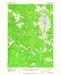
1961 Map of Mt. Jefferson
USGS Topo · Published 1963About this map
Mount Jefferson towers over this Cascades landscape, marking the junction of the Willamette National Forest, Mt Hood National Forest, and the Warm Springs Indian Reservation. In the early 1960s, this area was defined by its network of high-altitude trails and forest service outposts, including the Pamelia Lake Guard Sta and Marion Lake Guard Sta. The settlement at Marion Forks serves as a lone hub of activity along the North Santiam River, supported by a local Fish Hatchery.
Find a feature on this map
157 named features on this map. Tap any name to fly to it.
Don’t see what you’re looking for? This feature index may not catch every label — zoom into the map to look around manually.
Map Details
Editions of this 1961 Mt. Jefferson Map
3 editions found
Other maps of this area

1927 · Mt. Jefferson
USGS Topo · 1:125,000

1929 · Mill City
USGS Topo · 1:125,000

1929 · Three Sisters
USGS Topo · 1:125,000

1930 · Mt. Jefferson
USGS Topo · 1:125,000

1932 · Three Sisters
USGS Topo · 1:125,000

1934 · Mc Kenzie Bridge
USGS Topo · 1:96,000

1940 · Mc Kenzie Bridge
USGS Topo · 1:125,000

1953 · Salem
USGS Topo · 1:250,000

1954 · Salem
USGS Topo · 1:250,000

1955 · Echo Mountain
USGS Topo · 1:62,500