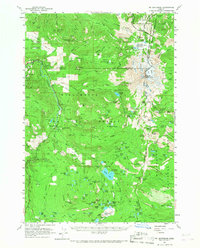
1961 Map of Mt. Jefferson
USGS Topo · Published 1967About this map
Mount Jefferson anchors the intersection of several wilderness boundaries, including the Mt Hood National Forest, Willamette National Forest, and the Deschutes National Forest. This high Cascades landscape is defined by its extensive network of peaks and water bodies, centered around the settlement of Marion Forks and the nearby Marion Forks Fish Hatchery. The map documents a period of active backcountry management, shown through the presence of multiple ranger stations such as the Pamelia Lake Guard Sta and Marion Lake Guard Sta.
Find a feature on this map
202 named features on this map. Tap any name to fly to it.
Don’t see what you’re looking for? This feature index may not catch every label — zoom into the map to look around manually.
Map Details
Editions of this 1961 Mt. Jefferson Map
3 editions found
Other maps of this area

1927 · Mt. Jefferson
USGS Topo · 1:125,000

1929 · Mill City
USGS Topo · 1:125,000

1929 · Three Sisters
USGS Topo · 1:125,000

1930 · Mt. Jefferson
USGS Topo · 1:125,000

1932 · Three Sisters
USGS Topo · 1:125,000

1934 · Mc Kenzie Bridge
USGS Topo · 1:96,000

1940 · Mc Kenzie Bridge
USGS Topo · 1:125,000

1953 · Salem
USGS Topo · 1:250,000

1954 · Salem
USGS Topo · 1:250,000

1955 · Echo Mountain
USGS Topo · 1:62,500