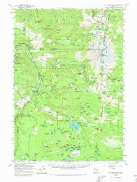
1961 Map of Mt. Jefferson
USGS Topo · Published 1980About this map
Mount Jefferson stands as the dominant physical landmark on this mid-century survey of the Oregon Cascades, straddling the boundaries of Marion, Jefferson, and Linn counties. The map details a landscape defined by high-altitude glaciers like Waldo Glacier and Jefferson Park Glacier, draining into complex water systems including the South Fork Breitenbush River and Whitewater Creek. Human presence is largely tied to forest management and early recreation, evidenced by the Fish Hatchery and Guard Station at Marion Forks. The primitive infrastructure of the era is captured through routes like the Oregon Skyline Trail and Minto Driveway, which provided access to remote features such as Boca Cave and Pamelia Lake. This record preserves the location of specific forest landmarks including Flapper Springs Guard Station and the distinctive geological formation of The Table before modern development altered wilderness access patterns.
Find a feature on this map
171 named features on this map. Tap any name to fly to it.
Don’t see what you’re looking for? This feature index may not catch every label — zoom into the map to look around manually.
Map Details
Editions of this 1961 Mt. Jefferson Map
3 editions found
Other maps of this area

1927 · Mt. Jefferson
USGS Topo · 1:125,000

1929 · Mill City
USGS Topo · 1:125,000

1929 · Three Sisters
USGS Topo · 1:125,000

1930 · Mt. Jefferson
USGS Topo · 1:125,000

1932 · Three Sisters
USGS Topo · 1:125,000

1934 · Mc Kenzie Bridge
USGS Topo · 1:96,000

1940 · Mc Kenzie Bridge
USGS Topo · 1:125,000

1953 · Salem
USGS Topo · 1:250,000

1954 · Salem
USGS Topo · 1:250,000

1955 · Echo Mountain
USGS Topo · 1:62,500