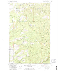
1973 Map of Mt. Kit Carson
USGS Topo · Published 1984About this map
Mt Spokane State Park dominates this topography, where the landscape transitions from the peaks of Mt Kit Carson and Day Mountain into a complex network of drainage basins. The area’s mid-century character is defined by a mix of recreational land and rural utility, evidenced by scattered Mine sites and the Daybreak Mine situated near the headwaters of Cottonwood Creek. Small community hubs like Nelson and the Grange Hall near Madison Rd anchor the northwestern corner, while family-named locales such as the St Charles Ranch and Tallman indicate the legacy of local landholding. The hydrological pattern is particularly intricate, with the Little Missouri Creek and its various forks, including Hells Hole Creek, carving through the southern ridges. This 1973 field-checked survey captures the region just as fire roads and pack trails were becoming the primary means of navigating the high timber and mountain gaps.
Find a feature on this map
43 named features on this map. Tap any name to fly to it.
Don’t see what you’re looking for? This feature index may not catch every label — zoom into the map to look around manually.
Map Details
Editions of this 1973 Mt. Kit Carson Map
3 editions found
Other maps of this area

1901 · Spokane
USGS Topo · 1:125,000

1936 · Newport
USGS Topo · 1:96,000

1942 · Newport
USGS Topo · 1:125,000

1943 · Mt Spokane
USGS Topo · 1:62,500

1949 · Deer Park
USGS Topo · 1:62,500

1950 · Mt Spokane
USGS Topo · 1:62,500

1951 · Deer Park
USGS Topo · 1:62,500

1955 · Spokane
USGS Topo · 1:250,000

1958 · Spokane
USGS Topo · 1:250,000

1958 · Sandpoint
USGS Topo · 1:250,000