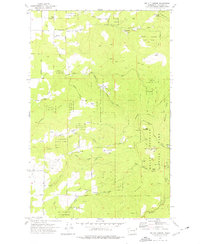
1973 Map of Mt. Kit Carson
USGS Topo · Published 1977About this map
Mt Spokane State Park dominates this Spokane County landscape, characterized by high-elevation peaks and an intricate network of specialized routes including Jeep Trails and Pack Trails. The terrain is defined by prominent elevations such as Mt Kit Carson, Day Mountain, and Beauty Mtn, with the deep drainage of Blanchard Creek and Deer Creek cutting through the slopes.
Find a feature on this map
48 named features on this map. Tap any name to fly to it.
Don’t see what you’re looking for? This feature index may not catch every label — zoom into the map to look around manually.
Map Details
Editions of this 1973 Mt. Kit Carson Map
3 editions found
Historical Maps of Spokane County Through Time
78 maps found

1943 Mt Spokane
Spokane County, WA

1949 Greenacres
Spokane County, WA

1950 Mt Spokane
Spokane County, WA

1950 Spokane NE
Spokane County, WA

1950 Spokane NW
Spokane County, WA

1950 Spokane SE
Spokane County, WA

1950 Spokane SW
Spokane County, WA

1951 Greenacres
Spokane County, WA

1954 Deep Creek
Spokane County, WA

1963 Deep Creek
Spokane County, WA

1963 Spokane NE
Spokane County, WA

1963 Spokane NW
Spokane County, WA

1963 Spokane SE
Spokane County, WA

1963 Spokane SW
Spokane County, WA

1968 Fan Lake
Spokane County, WA

1973 Chattaroy
Spokane County, WA

1973 Dartford
Spokane County, WA

1973 Deep Creek
Spokane County, WA

1973 Foothills
Spokane County, WA

1973 Four Mound Prairie
Spokane County, WA

1973 Freeman
Spokane County, WA

1973 Greenacres
Spokane County, WA

1973 Mica Peak
Spokane County, WA

1973 Mt. Kit Carson
Spokane County, WA

1973 Mt Spokane
Spokane County, WA

1973 Newman Lake
Spokane County, WA

1973 Nine Mile Falls
Spokane County, WA

1973 Reardan East
Spokane County, WA

1973 Spokane NE
Spokane County, WA

1973 Spokane SE
Spokane County, WA

1973 Spokane SW
Spokane County, WA

1973 Waukon
Spokane County, WA

1974 Spokane NW
Spokane County, WA

1975 Greenacres NE
Spokane County, WA

1978 Greenacres
Spokane County, WA

1978 Newman Lake
Spokane County, WA

1978 Spokane NE
Spokane County, WA

1978 Spokane NW
Spokane County, WA

1980 Chapman Lake
Spokane County, WA

1980 Lance Hills
Spokane County, WA

1980 Plaza
Spokane County, WA

1980 Spangle West
Spokane County, WA

1980 Spring Valley
Spokane County, WA

1980 Tekoa Mountain
Spokane County, WA

1980 Tyler
Spokane County, WA

1981 Amber
Spokane County, WA

1981 Fishtrap Lake
Spokane County, WA

1981 Spangle East
Spokane County, WA

1996 Mount Spokane
Spokane County, WA

2023 Amber
Spokane County, WA

2023 Chapman Lake
Spokane County, WA

2023 Chattaroy
Spokane County, WA

2023 Dartford
Spokane County, WA

2023 Deep Creek
Spokane County, WA

2023 Fan Lake
Spokane County, WA

2023 Fishtrap Lake
Spokane County, WA

2023 Foothills
Spokane County, WA

2023 Four Mound Prairie
Spokane County, WA

2023 Freeman
Spokane County, WA

2023 Greenacres
Spokane County, WA

2023 Lance Hills
Spokane County, WA

2023 Mica Peak
Spokane County, WA

2023 Mount Kit Carson
Spokane County, WA

2023 Mount Spokane
Spokane County, WA

2023 Newman Lake
Spokane County, WA

2023 Nine Mile Falls
Spokane County, WA

2023 Plaza
Spokane County, WA

2023 Reardan East
Spokane County, WA

2023 Spangle East
Spokane County, WA

2023 Spangle West
Spokane County, WA

2023 Spokane NE
Spokane County, WA

2023 Spokane NW
Spokane County, WA

2023 Spokane SE
Spokane County, WA

2023 Spokane SW
Spokane County, WA

2023 Spring Valley
Spokane County, WA

2023 Tekoa Mountain
Spokane County, WA

2023 Tyler
Spokane County, WA

2023 Waukon
Spokane County, WA