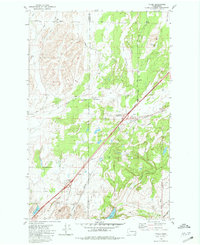
1980 Map of Tyler
USGS Topo · Published 1981About this map
The boundary between Lincoln and Spokane Counties divides this landscape of scabland terrain and small-scale agriculture. The community of Tyler serves as a central hub, situated along the Burlington Northern railroad line and the modern path of the Tyler-Cheney Interchange. To the southwest, the settlement of Fishtrap and its corresponding Fishtrap Interchange mark a critical node for transport and regional access during the late twentieth century.
Find a feature on this map
26 named features on this map. Tap any name to fly to it.
Don’t see what you’re looking for? This feature index may not catch every label — zoom into the map to look around manually.
Map Details
Editions of this 1980 Tyler Map
This is the sole edition of this map. No revisions or reprints were ever made.
Other maps of this area

1943 · Medical Lake
USGS Topo · 1:62,500

1945 · Reardan
USGS Topo · 1:62,500

1953 · Reardan
USGS Topo · 1:62,500

1954 · Medical Lake
USGS Topo · 1:24,000

1954 · Medical Lake
USGS Topo · 1:62,500

1954 · Cheney
USGS Topo · 1:62,500

1954 · Sprague
USGS Topo · 1:62,500

1955 · Spokane
USGS Topo · 1:250,000

1958 · Spokane
USGS Topo · 1:250,000
1963 · Medical Lake
USGS Topo · 1:24,000