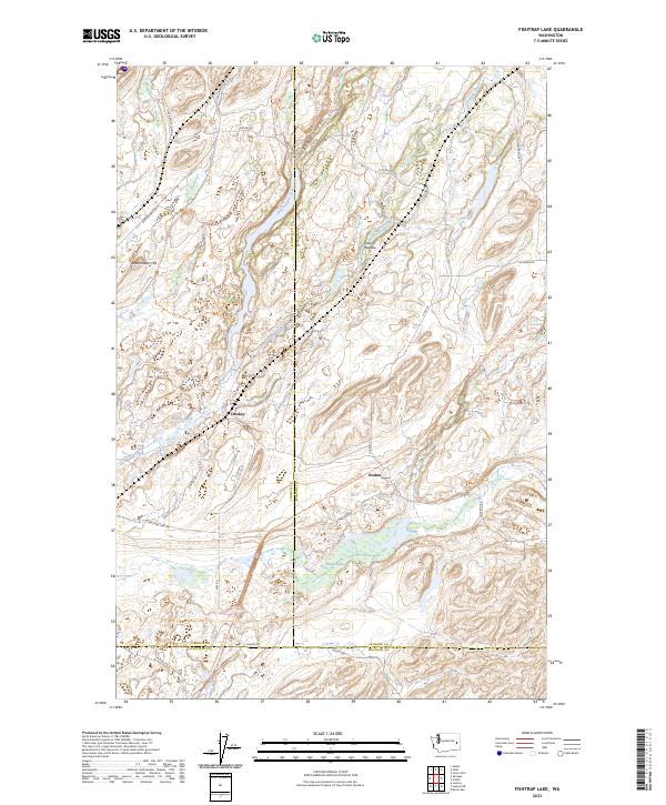
2023 Map of Fishtrap Lake
USGS Topo · Published 2023About this map
Hog Canyon Creek and Negro Creek carve through this landscape at the intersection of Lincoln, Spokane, and Whitman counties. This corner of the Channeled Scablands is defined by its drainage patterns and small water bodies like Downs Lake and Clear Lake, reflecting the unique geological history of the region. The modern cartography highlights the Columbia Plateau State Park Trl, which follows a long-standing transportation corridor through the settlements of Croskey and Rodna. These small communities and the network of rural roads, such as Lake Valley Loop Rd and Sprague Hwy Rd E, illustrate the persistent agricultural and transit patterns of eastern Washington. Named landmarks like Watermelon Hill and Owens Meadow provide specific points of reference for local historians and genealogists tracking family landholdings in the tri-county area.
Find a feature on this map
34 named features on this map. Tap any name to fly to it.
Don’t see what you’re looking for? This feature index may not catch every label — zoom into the map to look around manually.
Map Details
Editions of this 2023 Fishtrap Lake Map
This is the sole edition of this map. No revisions or reprints were ever made.
Other maps of this area

1954 · Cheney
USGS Topo · 1:62,500

1954 · Sprague
USGS Topo · 1:62,500

1955 · Spokane
USGS Topo · 1:250,000

1958 · Spokane
USGS Topo · 1:250,000

1964 · Lamont NE
USGS Topo · 1:24,000

1964 · Lamont NW
USGS Topo · 1:24,000

1964 · Rock Lake
USGS Topo · 1:24,000
1980 · Sassin
USGS Topo · 1:24,000
1980 · Lance Hills
USGS Topo · 1:24,000
1980 · Tyler
USGS Topo · 1:24,000