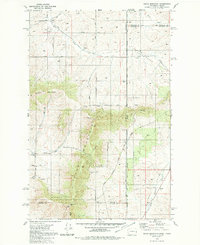
1980 Map of Tekoa Mountain
USGS Topo · Published 1981About this map
Tekoa Mountain dominates this landscape along the border of Washington and Idaho, serving as a prominent topographic anchor where several counties converge. The 1980 survey captures the region's complex administrative geography, showing the Coeur D'Alene Indian Reservation Boundary as it intersects the lines of Spokane, Whitman, Kootenai, and Benewah counties. Transportation networks are defined by the Chicago Milwaukee St Paul and Pacific rail line and an Old Railroad Grade that snakes through the southern terrain, reflecting the area's history of heavy transit and timber or agricultural extraction.
Find a feature on this map
31 named features on this map. Tap any name to fly to it.
Don’t see what you’re looking for? This feature index may not catch every label — zoom into the map to look around manually.
Map Details
Editions of this 1980 Tekoa Mountain Map
This is the sole edition of this map. No revisions or reprints were ever made.
Other maps of this area

1903 · Oakesdale
USGS Topo · 1:125,000

1905 · Oakesdale
USGS Topo · 1:125,000

1954 · Fairfield
USGS Topo · 1:62,500

1955 · Spokane
USGS Topo · 1:250,000

1957 · Plummer
USGS Topo · 1:62,500

1957 · Tensed
USGS Topo · 1:62,500

1958 · Spokane
USGS Topo · 1:250,000

1964 · Oakesdale
USGS Topo · 1:24,000

1964 · Tekoa
USGS Topo · 1:24,000

1975 · Plummer NW
USGS Topo · 1:24,000