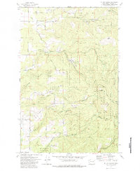
1973 Map of Mt. Kit Carson
USGS Topo · Published 1984About this map
Mt Spokane State Park dominates this terrain in the early 1970s, showcasing a landscape defined by significant elevation changes and the headwaters of numerous drainages. The area is anchored by prominent peaks like Mt Kit Carson and Day Mountain, which are connected by high ridges such as Missouri Ridge and Hay Ridge. This survey reveals a transition from the structured recreational spaces of the park to the working landscape of the surrounding Spokane County countryside, where several extractive sites like the Daybreak Mine and scattered prospects are noted. Settlement is sparse, represented by localized landmarks such as the Grange Hall and the Mt St Charles Ranch. A complex network of creek systems, including Blanchard Creek and the Little North Fork Deep Creek, carves through the topography, with named features like Hells Hole and Smith Gap marking the difficult passes between the high-altitude forests and the lower meadows.
Find a feature on this map
46 named features on this map. Tap any name to fly to it.
Don’t see what you’re looking for? This feature index may not catch every label — zoom into the map to look around manually.
Map Details
Editions of this 1973 Mt. Kit Carson Map
3 editions found
Other maps of this area

1901 · Spokane
USGS Topo · 1:125,000

1936 · Newport
USGS Topo · 1:96,000

1942 · Newport
USGS Topo · 1:125,000

1943 · Mt Spokane
USGS Topo · 1:62,500

1949 · Deer Park
USGS Topo · 1:62,500

1950 · Mt Spokane
USGS Topo · 1:62,500

1951 · Deer Park
USGS Topo · 1:62,500

1955 · Spokane
USGS Topo · 1:250,000

1958 · Spokane
USGS Topo · 1:250,000

1958 · Sandpoint
USGS Topo · 1:250,000